Modernizing AEC with GIS: Turning Location into Your Competitive Advantage

Every great structure begins with a question: What exists here today, and what can we build tomorrow?
Before the first block is laid. Before the first beam rises. Before the first machine roars to life, there is location.
And in today’s fast-moving Architecture, Engineering, and Construction (AEC) sector, location is no longer just a reference point, it’s a strategic advantage.
This is where Geographic Information Systems (GIS) steps in, not as a support tool, but as a digital backbone for modern construction.
At Sambus Geospatial, we see GIS not just as a mapping tool, but as the bridge that connects design, engineering, construction, operations, and long-term asset management into one intelligent, living system.
Construction Is Spatial; Why Keep Data in Silos?
Construction is inherently spatial. Every pipe has coordinates. Every foundation has boundaries. Every road, tower, bridge, and power line exists somewhere on the earth’s surface.
Yet for decades, construction data has lived in disconnected silos:
- Design data in CAD and BIM software
- Site data in spreadsheets
- Progress reports in emails
- Inspections on paper
- Sensor data locked inside machines
The result?
Gaps in communication, avoidable delays, cost overruns, and blind decision-making.
GIS CHANGES THAT.
By connecting location with engineering, cost, time, risk, and performance, GIS creates a single, shared truth across the entire project lifecycle, from site selection to design, construction, and operations.
From Site Selection to Smart Cities: GIS at Every Stage
Smarter Planning Starts with Better Context
Before a project begins, GIS allows teams to:
- Analyze terrain, topography, and soil conditions
- Assess flood risks and environmental constraints
- Understand utilities, roads, and adjacent infrastructure
- Evaluate accessibility, population, and land use
With ArcGIS Pro, ArcGIS Online, and advanced spatial analytics, project teams no longer guess, they simulate before they build.
This alone can save millions on rework, redesign, and dispute resolution.
When BIM, CAD, and GIS Finally Speak the Same Language
One of the most powerful shifts in modern construction is the fusion of BIM, CAD, and GIS.
With tools like:
- ArcGIS for AutoCAD
- ArcGIS GeoBIM
- ArcGIS Pro (3D & Spatial Analysis)
- And integrations with drones, site sensors, and GNSS survey systems
Design models no longer float in isolation. They now sit inside the real world.
Engineers can now:
- View BIM models in true geographic context
- Compare designs against real-world terrain and constraints
- Detect clashes between underground utilities and new foundations
- Validate accessibility, safety, and constructability before ground is broken
This is how spatial intelligence eliminates expensive surprises.

BIM data in context of reality capture mesh. BIM data courtesy and copyright OSU Facilities team. I3S mesh courtesy Nearmap
Digital Twins: When Your Asset Lives Twice
Imagine having a real-time, living digital replica of your project before, during, and long after construction.
That’s the promise of Digital Twins, powered by GIS.
By integrating:
- IoT sensors
- Live site updates
- Drone imagery
- BIM models
- Environmental data
GIS becomes the spatial engine behind digital twins, allowing teams to:
- Monitor progress remotely
- Predict failures before they happen
- Optimize maintenance schedules
- Track performance over the full asset lifecycle
From rail systems to highways, smart buildings to utilities, digital twins are no longer futuristic, they’re the new industry standard.
The Office and the Field Finally in Sync
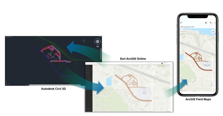
Synchronize office and field teams with integrated CAD data and mobile apps for field operations
In modern construction, decisions move at the speed of data.
With ArcGIS mobile field applications:
- Inspectors capture site conditions in real time
- Safety officers log incidents instantly
- Supervisors track daily progress digitally
- Engineers receive updates without delay
And through the ArcGIS System as a Single Source of Truth, office teams and field teams see the same data, at the same time.
No more:
- Conflicting reports
- Delayed updates
- Costly miscommunication
Only Clarity, Speed, and Confidence.
Turning Complex Projects into Clear Stories
Construction doesn’t just need data, it needs understanding.
With:
- ArcGIS Dashboards for live performance visibility
- ArcGIS StoryMaps for visual storytelling
- Project Hub Portals for secure stakeholder access
Project teams can:
- Communicate progress to executives
- Engage regulators and host communities
- Align investors and partners
- Build public trust through transparency
Now, even non-technical stakeholders can see, understand, and track progress in real time.
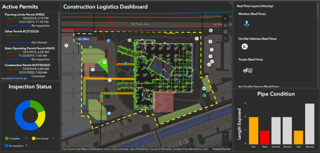
Interactive dashboards provide a visual, real-time view of project data, helping teams track progress, monitor performance, and make informed decisions
Where Sambus Geospatial Comes In
At Sambus Geospatial, we don’t just deploy software.
We design intelligent AEC ecosystems.
By combining:
Esri’s Robust ArcGIS system
With Spatial Data Acquisition Technologies in:
- Drones & reality capture
- Survey & positioning systems
- IoT & sensor networks
- 3D modeling & visual analytics
We help AEC organizations move from disconnected tools to fully integrated digital workflows and predictive intelligence.
Whether you’re designing a highway, constructing a smart estate, managing utilities, or operating critical infrastructure, we help you see more, decide faster, and build smarter.
The Future of AEC Is Not Just Digital, It’s Spatial
The next era of construction is being shaped by:
- Smart cities
- Climate-resilient infrastructure
- Carbon-aware design
- Predictive maintenance
- Automated construction
- AI-driven geospatial analytics
And at the heart of all of it is location intelligence.
Because when we understand where a structure is, we unlock everything about how it should be designed, built, operated, and sustained.
Final Thoughts
GIS is no longer a back-office tool.
It is now:
- A strategy engine
- A risk management system
- A collaboration platform
- And a foundation for digital twins and smart infrastructure
For forward-thinking AEC organizations, GIS is not optional, it’s essential.
And at Sambus Geospatial, we’re helping build this future, one location-powered project at a time.
If you’re ready to build with clarity, insight, and confidence, GIS is your next strategic move.
Like to know more?
We’d love to hear from you! 🤗
Fill out the form below to share your thoughts or request a free consultation with our experts. Discover how GIS can streamline your workflows, boost collaboration, and elevate your project outcomes.
👉 Click here
References
- Esri Community Maps – Retrieved December 2025, from https://www.esri.com/en-us/arcgis/products/community-maps
- Esri Blog – Retrieved December 2025, from https://www.esri.com/arcgis-blog/
- Esri Website – Retrieved December 2025, from https://www.esri.com
- ArcGIS Products & Capabilities – ArcGIS Pro, ArcGIS Online, ArcGIS GeoBIM, ArcGIS StoryMaps, ArcGIS Dashboards. Retrieved December 2025, from https://www.esri.com/en-us/arcgis/products
- Digital Twins in Construction – Retrieved December 2025, from https://www.esri.com/en-us/industries/construction/digital-twins
Image Attribution
Figure Images used in this blog are from the Esri website.
Image Credit: © Esri. Used with permission. https://www.esri.com