Beyond the Hype: How GeoAI Creates Lasting Value for Organizations
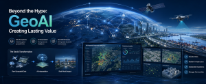
Artificial Intelligence is everywhere.
Every day, organizations generate massive amounts of data. Yet many still struggle to answer a simple question: Where should we act next?
While most conversations about AI focus on chatbots and content generation, some of the most transformative applications are happening in a different space entirely where location, intelligence, and decision-making converge.
This is especially true in the geospatial world, with the adoption of GeoAI.
GeoAI combines Geographic Information Systems (GIS), remote sensing, drones, satellite imagery, and Artificial Intelligence to help organizations understand not just what is happening, but where it is happening and why it matters.
And increasingly, it is changing how governments, businesses, utilities, and infrastructure operators make decisions.
GeoAI Is Already Closer Than You Think
Across Africa, governments are using geospatial intelligence:
- To improve urban planning
- Utilities are modernizing asset management
- Environmental agencies are monitoring land-use changes at unprecedented scale
Traditionally, these tasks required teams of specialists reviewing maps, imagery, spreadsheets, and reports.
Today, AI can assist in identifying patterns, highlighting anomalies, and accelerating analysis that would otherwise take days or weeks.
The result is faster insight, better situational awareness, and more informed decision-making.
From Maps to Intelligent Decision Support
For years, GIS has helped organizations answer questions like:
- What is happening?
- Where is it happening?
- How has it changed over time?
GeoAI takes this a step further.
It helps organizations explore:
- Why is this happening?
- What patterns are emerging?
- What should we pay attention to next?
Modern GIS platforms are increasingly embedding AI directly into everyday workflows.
Notably, ArcGIS users can now leverage AI-powered ArcGIS Pro assistant that help answer documentation questions, generate code, build expressions, and guide workflow development directly within their GIS environment.
This reduces the learning curve and allows teams to focus more on solving problems and less on navigating technical complexity.
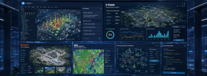
fig 1: AI-Embedded GIS Workflows (Connected Geospatial Intelligence Ecosystem)
Seeing More Through Imagery
Every day, satellites, drones, and sensors capture enormous amounts of information about our world.
The challenge is no longer collecting data.
The challenge is making sense of it.
This is where AI-powered imagery analysis becomes valuable.
Advanced geospatial tools can automatically identify buildings, roads, vegetation, damaged infrastructure, and other features from imagery that would traditionally require extensive manual interpretation.
Instead of spending hours digitizing features, analysts can focus on validating results and extracting insights.
For organizations managing large geographic areas, this can dramatically improve efficiency.
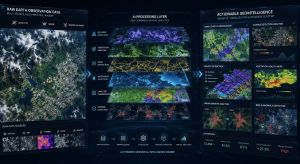
fig 2: Making Sense of the World Through Imagery Intelligence
The Rise of Intelligent Drones
Drones have become one of the most powerful sources of geospatial data.
But modern drone workflows go far beyond aerial photography.
Today’s surveying platforms can collect highly accurate photogrammetry, LiDAR, and multispectral datasets that feed directly into AI-enabled analysis workflows.
This allows organizations to monitor assets, assess vegetation health, track construction progress, generate 3D models, and inspect infrastructure with greater speed and precision.
Rather than simply capturing images, drones are becoming part of intelligent decision-making ecosystems.
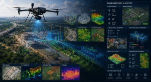
fig 3: The Rise of Intelligent Drone Ecosystems
When AI Understands Geography
One of the biggest challeng
es with technology is usability.
Many organizations have valuable data but lack the specialized expertise needed to unlock its full potential.
A new generation of geospatial AI tools is helping bridge that gap.
Contrary to navigating complex processes and workflows, users can increasingly interact with systems using natural language.
Imagine asking software to identify areas of land cover change, detect features in imagery, or perform a remote sensing workflow using plain language instructions.
Technology handles much of the complexity behind the scenes while users remain focused on outcomes.
This makes advanced geospatial analysis more accessible to a wider range of professionals.
GeoAI Beyond Mapping
GeoAI is not limited to GIS departments.
Its influence is expanding across industries.
- Transportation organizations are using AI to forecast network demands and optimize operations.
- Construction teams are leveraging AI-powered reality capture and automated quantity extraction to improve project delivery.
- Utilities are using AI-assisted monitoring to better manage critical infrastructure.
- Environmental agencies are combining satellite imagery and AI to track changes across large geographic areas.
In each case, the goal is the same:
Transform large volumes of data into actionable intelligence.
The Organizations Creating the Most Value with GeoAI
The most successful organizations are not simply adopting AI because it is trending.
They are embedding AI into everyday workflows where it can help people make better decisions.
They combine trusted data, geospatial context, skilled professionals, and intelligent tools.
Most importantly, they view GeoAI as a capability rather than a project.
Technology will continue to evolve.
New AI models will emerge.
Data volumes will grow.
But organizations that build strong foundations today will be best positioned to take advantage of future opportunities.
The future of AI is not simply about automation. It is about making better decisions with greater confidence.
Organizations that combine AI with geospatial intelligence will be better equipped to manage infrastructure, optimize resources, respond to change, and create lasting value.
At Sambus Geospatial, we help organizations move beyond the promise of GeoAI and turn it into measurable business outcomes through industry-leading geospatial technologies, AI-powered analytics, remote sensing, and implementation expertise.
Ready to move beyond the hype and unlock the real value of GeoAI from a technology initiative into a strategic capability?
We’d love to start the conversation. Get in touch with us @👉 Sambus Geospatial to discover what’s possible.