How GIS Supports West Africa Achieve Sustainability

Across West Africa, governments, businesses, and development organizations are working to address some of the region’s most pressing challenges: poverty, food insecurity, rapid urbanization, inadequate infrastructure, environmental degradation, and the growing impacts of climate change.
From Gambia to Equatorial Guinea, leaders are seeking smarter ways to allocate resources, improve public services, and accelerate economic development.
One technology is increasingly proving essential in this effort: Geographic Information Systems (GIS).
GIS helps organizations understand the relationship between people, places, and resources. By combining maps with real-world data, GIS enables decision-makers to see patterns, identify opportunities, and solve problems more effectively.
For West Africa, where development challenges often vary significantly from one location to another, understanding “where” is just as important as understanding “what.”
Which communities still lack access to clean water? Where should new schools, hospitals, or roads be built? Which areas are most vulnerable to flooding? Where are farmers likely to experience crop failures? Which communities are underserved by financial or telecommunications services?
The answers to these questions depend heavily on location.
GIS provides a visual and analytical framework for making better decisions by showing where challenges exist and where interventions will have the greatest impact.
Resolving West Africa’s Biggest Challenges One Goal At A Time

-
Reducing Poverty Through Better Targeting (SDG 1)
One of the biggest challenges in West Africa is ensuring that development investments reach the communities that need them most.
In Ghana, spatial data has been used to support poverty mapping and development planning, helping policymakers identify underserved districts and prioritize investments in education, healthcare, and infrastructure.
Similarly, development agencies working across the Sahel have used GIS to map vulnerable communities and improve the targeting of social protection programmes.
For governments and donor organizations, GIS helps answer a critical question: Are resources reaching the people who need them most?
By identifying geographical disparities, decision-makers can design interventions that are more equitable and effective.
-
Strengthening Food Security and Agriculture (SDG 2)
Agriculture remains the backbone of many West African economies, employing millions of people and contributing significantly to national GDP. Yet farmers face increasing pressure from climate change, droughts, flooding, and land degradation.
GIS is helping transform agricultural planning through:
- Crop monitoring using satellite imagery
- Soil suitability assessments
- Drought monitoring
- Irrigation planning
- Yield forecasting
In northern Ghana and parts of northern Nigeria, geospatial technologies have been used to monitor vegetation conditions and assess drought risks, helping governments and development organizations respond before food shortages become severe.
In Senegal, GIS-supported land management initiatives have helped improve agricultural planning and resource allocation.
For agribusinesses, location intelligence can help identify productive farming zones, optimize supply chains, and reduce operational risks.
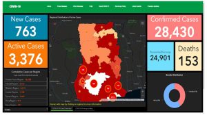
COVID-19 dashboard developed for the Ghana Health Service
-
Improving Healthcare Access (SDG 3)
The COVID-19 pandemic highlighted the importance of location intelligence in public health management. Across West Africa, GIS was used to map cases, monitor disease spread, and support emergency response planning.
Beyond pandemics, GIS continues to play an important role in healthcare delivery. In Ghana and Sierra Leone, health authorities have used GIS to map healthcare facilities and identify communities with limited access to medical services. This information helps planners determine:
- Where new clinics should be built
- Which communities face long travel times to healthcare facilities
- Where health resources should be deployed during emergencies
For rapidly growing populations, these insights can significantly improve healthcare accessibility and outcomes.
-
Expanding Access to Clean Water and Sanitation (SDG 6)
Millions of people across West Africa still face challenges accessing reliable sources of clean water. GIS helps governments, water utilities, and development partners map water infrastructure, identify service gaps, and prioritize investments. For example, water utilities in Ghana have increasingly adopted GIS for managing pipelines, tracking infrastructure assets, and planning network expansion.
Development organizations have also used GIS to map boreholes and water points across rural communities in countries such as Liberia and Sierra Leone. This helps ensure that investments are directed toward communities with the greatest need.
-
Building More Resilient Cities (SDG 11)
West Africa is one of the fastest urbanizing regions in the world. Cities such as Accra, Lagos, Abidjan, Dakar, and Kumasi continue to expand rapidly, creating opportunities as well as challenges. Urban planners are increasingly using GIS to:
- Monitor urban growth
- Manage land use
- Improve transportation planning
- Assess informal settlement expansion
- Support waste management
- Enhance emergency response
In Ghana, GIS has been widely used in land administration reforms and urban planning initiatives to improve land management and support orderly development.
In Lagos, geospatial technologies have played a critical role in transportation planning, flood risk assessment, and urban infrastructure management.
By helping city authorities understand how urban areas are changing, GIS supports smarter and more sustainable growth.
-
Supporting Climate Action and Disaster Management (SDG 13)
Climate change poses significant risks across West Africa. Coastal cities face erosion and rising sea levels, while inland communities are increasingly affected by droughts, floods, and changing rainfall patterns.
GIS provides the tools needed to understand and respond to these risks. For example:
- Flood-prone communities in Accra can be identified through spatial analysis and terrain modelling.
- Coastal vulnerability assessments can help planners protect communities along Ghana’s, Senegal’s, and Côte d’Ivoire’s coastlines.
- Early warning systems can combine weather data and GIS to improve disaster preparedness.
Following recurring floods in several West African cities, governments and development agencies have increasingly relied on GIS to support risk mapping and emergency planning. This allows leaders to move from reactive responses to proactive resilience-building.
-
Protecting Natural Resources and Ecosystems (SDGs 14 and 15)
West Africa’s forests, wetlands, rivers, and coastal ecosystems support millions of livelihoods. However, these natural resources face growing pressure from urban expansion, illegal mining, deforestation, and environmental degradation.
GIS helps monitor environmental changes and supports sustainable resource management.
In Ghana, geospatial technologies are being used to monitor the impact of illegal mining (“galamsey”) on forests and water bodies.
Across the region, satellite imagery is helping organizations track deforestation, coastal erosion, and land-use change. These insights enable governments and businesses to balance economic development with environmental sustainability.

Why Businesses Should Care
For many business leaders, sustainability and profitability are often viewed as separate objectives.
In reality, GIS helps achieve both.
Telecommunications companies can identify underserved markets. Financial institutions can better understand customer distribution. Utilities can optimize service delivery. Infrastructure developers can reduce project risks. Agribusinesses can improve productivity and supply chain efficiency.
At the same time, these investments contribute to broader development goals.
GIS enables organizations to make better decisions while creating measurable social and environmental impact.
The Way Forward for West Africa
West Africa’s development challenges are complex, but they are not impossible to solve.
What is needed is better information, better planning, and better decision-making.
GIS provides all three.
By helping leaders understand where challenges exist and where solutions will have the greatest impact, GIS is becoming an essential tool for sustainable development across the region.
As governments pursue national development agendas, businesses strengthen their ESG commitments, and development partners invest in long-term growth, geospatial technology will continue to play a vital role.
The future of sustainable development in West Africa will not be driven by data alone, it will be driven by location-based insights that turn data into action and action into impact.
There is more to be explored on the use of location technology in simplifying complex issues and advancing the growth of industries and communities across West Africa. On the 15th and 16th of September 2026, the largest gathering of policymakers, business leaders and innovators of geospatial technology will be hosted in Accra, Ghana to discuss using the technology in their various environments for the betterment of the sub-region as a whole.