Turning Student Projects Into Purposeful Innovation
From Classroom Projects to Real-World Change
In today’s world, the projects you submit for assignments can be more than just a way to pass an exam or earn a grade. Each one holds real ideas that can help our communities, our society, improve planning and solve at least one of the myriad of problems we see every day. But too often, these ideas stay in classrooms or end up forgotten after graduation.
The Esri Young Scholar Award (YSA) changes that. It gives students the chance to take their projects which make use of Geographic Information Systems (GIS) beyond school and shares them with the world.
To support potential applicants, here is an explanation of what the award is about and how students can turn their academic work into meaningful, world-class and award-winning projects.
What is the Esri Young Scholar Award?
The Esri Young Scholar Award is a global programme by Esri, the world’s leading provider of GIS software and company behind ArcGIS. It celebrates undergraduate and master’s students who apply ArcGIS to transform creative ideas into impactful solutions in our communities.
As Esri’s official partner in West Africa, Sambus Geospatial manages the award submission process across the region.
Each year, Sambus Geospatial selects one student per participating country based on:
- How creative the project is
- How relevant it is to our current situation across the world
- How well the project uses ArcGIS in the study analysis
Why The Award Is Important
Winning the YSA opens many doors. As an award winner, you stand a chance to receive:
- An all-expense paid trip to US to attend the Esri Education Summit and Esri User Conference (prior access to a current US visa is essential)
- International recognition for your work
- The opportunity to display your project at the Esri User Conference Map Gallery
- A free one-year ArcGIS Personal Use license
- An official award plaque from Esri
What’s more, you join a global community of GIS users making a difference.
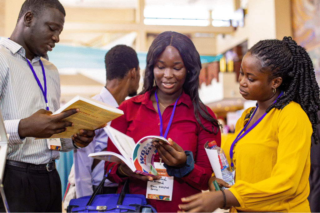
Local Projects Making A Difference
Past YSA winners have gone on to apply their innovative ideas in their respective careers.
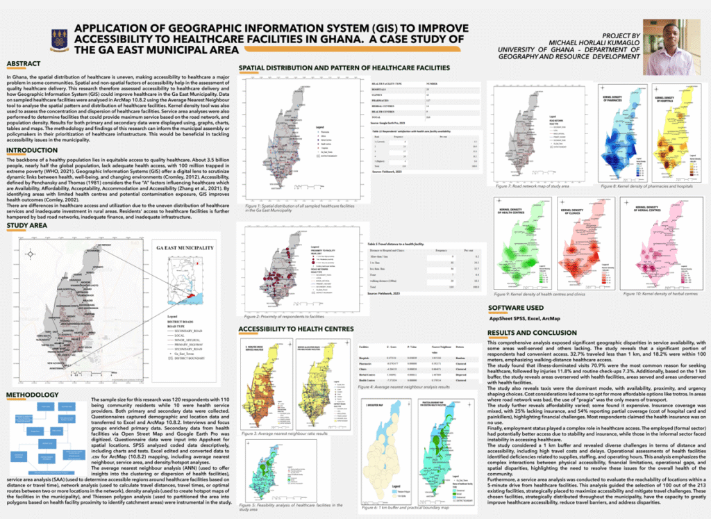
Poster for YSA Winning Project 2024
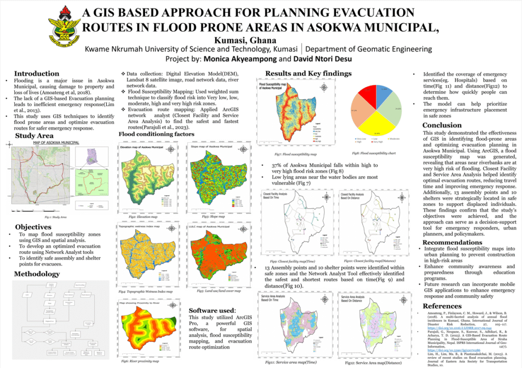
Poster for YSA Winning Project 2025
These show students assessing challenges we face in our society and their creativity in coming up with solutions driven by location intelligence and geospatial technology, particularly ArcGIS. Their work addressed the issue of flooding, environmental protection, and urban planning.
The projects did not just produce maps, they help us understand problems better and make smarter decisions using GIS.
How The Application Process Works
The selection process typically follows these steps:
1. We announce the call for applications
This usually happens in December or January.
2. We check project and applicant eligibility
Undergraduate or Master’s students under the age of 30 years.
3. Students submit their projects
Confirm you have the necessary documents, fully completed, before submitting your application.
4. A panel of judges reviews the submitted projects
The judges do this to assess the creativity and innovation of the projects.
5. We reach out to shortlisted applicants for an interview
This is to iron out the final details of the projects and the proficiency of the authors to bring out the strongest applicant.
6. We send the selected nominations to Esri
This is typically done in July.
7. We inform the winners of their award status
They are informed of the status of their application and supported in getting the necessary resources to access their award earnings.
Pro tip: Follow Sambus Geospatial online so you don’t miss the next call for applications.
What Makes A Strong Application?
A good Young Scholar Award submission should:
- Use any single software or combination of ArcGIS suite of software (for instance, ArcGIS Pro, ArcGIS Online, ArcGIS Dashboards, ArcGIS StoryMaps, and ArcGIS Survey123)
- Focus on a current problem in our society with clear indication of benefits or impact on our communities.
- Show original thinking, no copied work. We strongly discourage plagiarism in any form.
- Be clearly explained from problem to results.
- Use maps, dashboards and visuals to tell a clear story.
Pro tip: Common topics are okay; but your idea or method should stand out.
What To Avoid
Inasmuch as we want to propel your unique ideas to the global limelight, we wish to stress certain things we discourage you from doing. This is to help you create a kind of project worthy of international acclaim.
1. Group projects
Only individual work is allowed.
2. Poorly explained or unfinished projects
Rushed submissions often result in documents that have parts missing or unclear. We may not be able to reach out to you to understand what your intentions were in the project. Hence, we recommend that you take the time to proofread your work before submitting it.
3. Maps without analysis or insight
A picture, they say, is worth a thousand words. However, putting those words together helps others understand the picture you’re trying to create better.
4. Late submissions
Make sure you submit your application is submitted before the deadline. This allows you to re-submit in case you notice certain adjustments you need to make to the documents. In case you are having any trouble, feel free to send us a message on any of our social media channels.
Need Ideas?
Here are some topics you can check out:
- Healthcare and access to services
- Urban growth and planning
- Agriculture and food security
- Flooding and environmental risks
- Transport and mobility
- Climate change and resilience
You can also get ideas by attending GIS events, reading Esri blogs, or exploring the ArcGIS Living Atlas.
Your Idea Can Go Further
You don’t have to wait until graduation to make an impact. If you’re a student who enjoys solving real problems with maps and data, the Esri Young Scholar Award is a great place to start. To learn more:
- Watch our full webinar to learn from GIS professionals.
- Follow Sambus Geospatial on social media or join our mailing list for updates on when applications open.
Coming Soon… Esri User Conference West Africa 2026
The Esri User Conference West Africa 2026 is on its way! Happening in Accra, Ghana, 15-16 September 2026.
This event brings together GIS users, students, professionals, and decision-makers from across the region. It is a space to learn, share ideas, see new tools in action, and connect with the international geospatial community.
Expect:
- Practical sessions and demonstrations
- Real-life case studies
- Product showcases
- Opportunities to network and collaborate
More details coming soon. Stay connected and be part of what’s next in GIS across West Africa,