Harnessing Geospatial Technology to Support Early Flood Warning in Nigeria
The Geohazard Risk Mapping Initiative (GRMI) is a youth-led nonprofit organization aimed at mitigating the impacts of climate change in Nigeria through geospatial technology. Nigeria, the most populous country in Africa, is at the front line of climate change consequences, with its communities frequently facing destructive geohazards. Despite the Nigerian government’s commendable efforts to minimize these risks, a significant gap exists in disseminating early warning information and access to a real-time flood reporting tool. This gap precipitates a higher vulnerability to the escalating effects of climate change, particularly flooding. To address this challenge, GRMI has developed a strategic approach utilizing geospatial technology.
Climate change-induced environmental conditions pose significant threats to human lives and properties across African countries, particularly Nigeria. The country grapples with recurrent flooding, spurred by changes in rainfall patterns attributed to climate change and other human factors. According to the Centre for Research on the Epidemiology of Disasters (CRED), floods accounted for 43.5 per cent of all deaths from disasters in 2019, marking an increase in events compared to previous years. Furthermore, floods disrupt human activities and the economy, significantly affecting the most vulnerable populations. The lack of a flood reporting tool and an effective system for communicating early warning hazard information exacerbates these challenges, leaving communities unprepared and vulnerable to flooding.
GRMI & Africa Geoportal
Challenge
GRMI wanted to help support Nigerian communities in better understanding, preparing for, and responding to recurring flooding events spurred by changes in rainfall patterns attributed to climate change.
Solution
Using Africa Geoportal, Esri’s open GIS community data and mapping platform, GRMI created a real-time flood reporting tool, interactive flood maps, web applications, and a comprehensive flood event database.
Result
Communities and response organizations can now use the data, maps, and applications to better prepare for climate-related challenges like flooding.
Africa Geoportal
In alignment with Sustainable Development Goal 13 (Climate Action) and the Sendai Framework for Disaster Risk Reduction, GRMI was launched to address these issues. The initiative capitalizes on geographic information and satellite imagery analysis to provide vulnerability and emergency mapping of natural, biological, and technological hazards affecting African countries due to climate change.
Since its inception in September 2020, GRMI has assembled a team of 20 youth GIS volunteers skilled in hazard mapping.
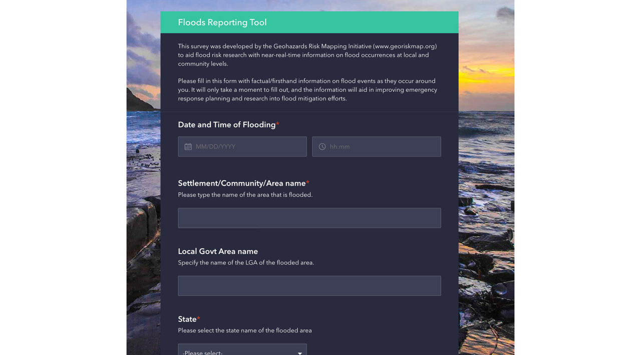
Using the form functionality of ArcGIS Survey123 on Africa Geoportal, the team created a user-friendly web flood reporting tool to report flooding events in real-time. This information is relayed to the national emergency agency, facilitating flood response in affected locations and contributing to a flood event database that can be used to mitigate future risks.
The team proceeded to produce high-precision static maps and digital interactive flood susceptibility maps using the data, analysis, and mapping tools available on Africa Geoportal.
Due to Africa Geoportal’s data-sharing capability and ability to amplify open data, these maps and applications could be shared easily with government institutions and local disaster management agencies and disseminated through various media platforms. Communities can interact with these maps and applications through a browser, which enables them to understand their level of susceptibility to flooding and make appropriate preparations.
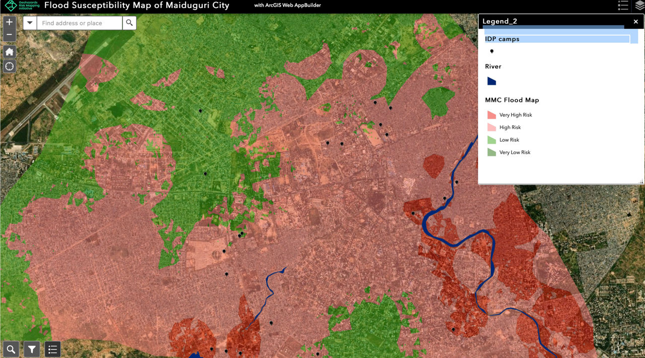 This interactive web application shows the flood susceptibility of Maiduguri City, Borno State, in northeastern Nigeria and the location of camps for internally displaced people. This map reveals that various camps are at high risk of future flooding.
Supporting Communities to Be Better Prepared
Since its launch, GRMI has mapped 25 communities across different states in Nigeria, significantly impacting disaster preparedness.
The initiative’s efforts are making a tangible difference in underrepresented communities. For instance, GRMI’s flood maps for Maiduguri Local Government Area revealed various internally displaced camps at risk of future flooding.
The Geohazard Risk Mapping Initiative is making significant strides in mitigating the impact of floods in Nigeria, and the benefits are plentiful. The flood maps produced by the initiative have offered insightful data that governments, communities, and individuals can use to better prepare for flood events. For instance, the maps reveal the level of flood susceptibility of various locations, including farmlands, schools, and marketplaces. This information is crucial in initiating preventive measures and reducing the damage caused by flood events.
Farmers, for instance, can use this information to plan their farming activities accordingly, thereby preventing food insecurity caused by unexpected flood events. Similarly, educational institutions can now use these maps to improve their emergency preparedness strategies, ensuring the safety of learners. Moreover, the susceptibility maps also guide the government and local planning agencies in making informed decisions about infrastructure development and land-use planning.
GRMI’s user-friendly web app has significantly improved the flood reporting process in Nigeria, enabling real-time data sharing with national emergency agencies.
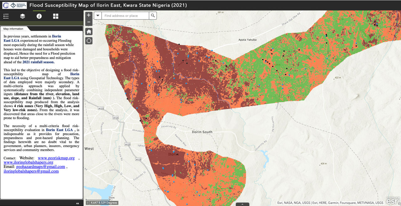 Flood risk susceptibility map of Ilorin East, Kwara State, Nigeria
Call to Action and Next Steps
The Geohazard Risk Mapping Initiative has already made great strides, but there is still much to be done. The initiative aims to convert its web app into a mobile app to enhance accessibility and ease of use. However, this project requires additional funding. As such, the call to action is for stakeholders, including governmental and non-governmental organizations, to provide the necessary support to realize this goal.
Moreover, the initiative is continually looking for more volunteers who have skills in geospatial analysis and environmental management to expand its reach to more communities. It is a great opportunity for young professionals to gain practical experience and contribute to a project with significant societal impact.
Lastly, community members are encouraged to utilize the flood reporting web app and share it with others. Every report contributes to the comprehensive flood event database and helps provide crucial data that can save lives and properties.
The Geohazards Risk Mapping Initiative is a testament to the power of geospatial technology in addressing climate change-related challenges. Through this initiative, Nigerian communities are better prepared to handle flooding, thereby reducing loss of life, property, and livelihoods. With additional support and resources, the initiative can continue to make an even more significant impact.