Using User-specified Coordinate Systems in ArcGIS GeoBIM Projects
Until the June 2023 release of ArcGIS GeoBIM, Web Mercator was the only supported coordinate system in ArcGIS GeoBIM that could be used to create feature layers, web maps, and issues. Now, you can select a base map with a different coordinate system for your ArcGIS GeoBIM Projects.
You must have a custom basemap gallery in your ArcGIS Online organization that hosts your own base maps in addition to Esri’s default base maps in Web Mercator. For more information, see the Create a custom basemap gallery for your organization blog article. To learn how to customize Esri vector base maps with your own colours, patterns, icons, and labels, follow the personalize your maps with custom basemap styles tutorial.
Understand map projections and coordinate systems
Transforming any geometry from a curved surface to a flat one involves a mathematical formula called map projection, since the earth is ellipsoid, and maps are flat. A map projection transforms latitude and longitude to x, and y coordinates (in feet or meters) in a projected coordinate system.
The process of flattening the earth causes distortions (see figure below) in several spatial properties, such as area and shape. There isn’t a perfect projection that can preserve all these spatial properties. As a result, all flat maps get distorted to some degree.
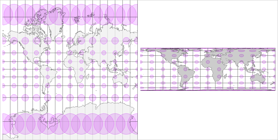 Map distortions in a world map in Web Mercator. The circles (Tissot’s indicatrices), and the squares near Ecuador are distorted as they move toward north and south.
Geographic information systems (GIS) allow you to choose from many map projections to best represent your map. Esri’s ArcGIS technology now supports 6,114 projected coordinate systems that use 106 different map projections. Each projection system is optimized to offer suitability for representing a particular portion of the earth’s surface.
Projection systems, as a result, aim to preserve distance, area, shape, or direction as close as possible to the real world. Some map projections minimize distortion in one property at the cost of another, while other ones strive to balance the overall distortion. As a GIS user, you can decide which properties are most important for your work and choose a projection that suits your needs.
Selecting the right coordinate system with the right projection is critical if you are doing the following:
- Aiming to make accurate measurements from your map and be sure that spatial analysis options calculate distance correctly.
- Making a map in which you want to preserve shape, area, distance, and direction properties.
- Using a particular projected coordinate system for all maps in your organization.
- Creating a small-scale map, such as a continental or world map. For a map that covers large areas, your choice of map projection determines its overall appearance. For example, with some projections, lines of latitude and longitude may appear curved, while others appear straight.
What’s new in ArcGIS GeoBIM
With the June 2023 release, ArcGIS GeoBIM adds the ability for you to select a coordinate system when creating ArcGIS GeoBIM Projects, along with adding any basemap available within your ArcGIS organization. Prior to this release, Web Mercator was the only supported coordinate system that ArcGIS GeoBIM allowed you to use to create feature layers, web maps, and issues. So, you can use any non-Web Mercator coordinate system in ArcGIS GeoBIM on your next project. ArcGIS GeoBIM updates include the following when using user-specified coordinate systems:
- A slightly different experience and user interface for the project creation in ArcGIS GeoBIM
- Additional project creation steps to select a basemap available in the custom basemap gallery group within your ArcGIS Online organization to define the spatial reference for the ArcGIS GeoBIM Project
- Support for all coordinate systems, including custom ones, with any functionality and tools in ArcGIS GeoBIM
- The ability to select any available basemap (in any coordinate system) in your organization to start an ArcGIS GeoBIM Project
- Automatically generated ArcGIS GeoBIM layers and ArcGIS GeoBIM web map in the selected coordinate system
Additionally, the default basemap and projected coordinate system in ArcGIS GeoBIM match the default for your organization.

What works as usual
The following have not changed:
- You can still change the basemap anytime in a project. This doesn’t affect the coordinate system of the generated ArcGIS GeoBIM feature layers. You can reproject them anytime.
- All ArcGIS GeoBIM functionalities and widgets respect the selected coordinate system.
- 3D Scene Layers must match the base map’s coordinate system in a local scene. 3D Scene Layers don’t support on-the-fly projection transformation yet.
