WHAT IS REMOTE SENSING?
Remote sensing is the science of collecting physical data about an object or area without having direct contact.
How does remote sensing work?
Remotely sensed data represents the amount of energy (electromagnetic radiation (EMR)) that is reflected or emitted by an object, usually something on the Earth’s surface.

How is remote sensing used?
Some specific uses of remotely sensed images of the Earth
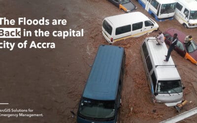
- Mapping disasters to provide critical information to responders
- Monitoring climate changes
- Detecting land use and land cover
Big Picture
Remote sensing techniques are used to capture information about a target without having to physically interact with it. This allows us to make observations that may not otherwise be possible. For example, visualizing things the human eye cannot see, measuring movement over long time periods and at tremendous spatial scales, and observing events in inaccessible areas.
Detailed Picture
Remote sensing measures the amount of EMR reflected in a particular wavelength (aka bands) to identify the characteristics of an object.
How is remote sensing used in different fields?
Remote sensing is used in numerous fields including geography, land surveying, and most Earth science disciplines. It is also used by militaries, intelligence communities, and commercial organizations for monitoring and planning humanitarian applications and much more.

What are the different remote sensing systems (active vs passive)?
Remote sensing uses sensors mounted on different platforms (spaceborne/airborne) to measure energy responses. Sensors are either active or passive. Active sensors illuminate a target with a known energy source and measure the time, phase, intensity, and other characteristics of the reflected energy. Passive sensors measure natural energy, usually sunlight, that is reflected or emitted from an object.

What are the different types of resolution (spatial, spectral, temporal)?
Spatial Resolution
Spatial resolution refers to the size of an object that can be seen in the image. High spatial resolution means one can see finer detail and resolve smaller objects. The low spatial resolution resolves fewer fine details and can only see larger targets.

Spectral Resolution
Spectral resolution refers to the number of bands collected by the sensor and how many unique wavelengths are included in each band. Higher spectral resolution (e.g., hyperspectral) has hundreds of narrow bands whereas lower resolution multispectral may only have a few wide bands. The higher the spectral resolution the more information that can be collected about chemical characteristics of a material.
Temporal Resolution
Temporal resolution is the amount of time it takes a sensor to image the same geographic area twice. For a satellite, that is the time it takes to complete a full orbit while with planes and drones, the time between captures is more flexible. The images collected over a specific interval are called multi-temporal data.
What is the electromagnetic spectrum?
The electromagnetic (EM) spectrum is the distribution of EM radiation based on frequency or wavelength.

Remote sensing measures frequencies both in the visible and non-visible spectrum. The visible spectrum includes frequencies that are seen as colors (red, green, and blue) by the human eye, which can only make sense of a very small portion of the full spectrum.
Why do you need to process and analyze remotely sensed data?
Geospatial data needs to be processed and analyzed to extract meaningful and actionable information from it. A picture may be worth a thousand words, but it takes several steps to get that picture talking in a language we can understand.

What is the image processing chain?
The image processing chain is a sequence of steps that are taken to glean meaningful information from imagery. The steps may vary sensor-to-sensor and project-to-project but normally consist of 1) Preprocessing: Preparation phase where raw data is converted into spatially and radiometrically accurate values. 2) Processing: Where questions can be asked of the data. For example, what is that material, how rough is that surface, and what is the height of an object? 3) Finally post-processing is the cleanup phase. This can be done by removing any errors and preparing the results for further analysis. It is important to note that each time we process data artifacts, noise can be introduced that could propagate throughout the chain.
What is image classification?
Image classification is the process of assigning classes to features in the image. The more spectral bands there are, the more nuanced the classes can be in the image classification. The goal of image classification is to produce land use/land cover. Remote sensing software, like ENVI® image processing and analysis software, is used to classify water, wetlands, trees, urban areas and much more.


