AI-Driven Mineral Exploration with GeoAgent
Mineral exploration has always required a careful balance of science, experience, capital, and risk. Today, that balance is shifting as artificial intelligence and advanced geospatial analytics become part of mainstream exploration workflows. According to industry studies, remote sensing and AI-driven targeting can reduce early-stage exploration costs by up to 30–50 percent by narrowing search areas and improving target confidence before field deployment.
However, this transformation does not come without challenges. Data quality, availability of suitable imagery, computing resources, and the need for user training all influence outcomes. AI models are only as reliable as the data and assumptions behind them, and organizations must invest in governance and skills development to fully realize value. When applied responsibly, these technologies can significantly improve decision-making and reduce exploration risk.
At the center of this shift is ENVI, NV5’s advanced geospatial analytics platform, now enhanced by the newly introduced AI-powered GeoAgent.
Turning Large Volumes of Data into Clear Direction
Field exploration is expensive and often constrained by terrain, accessibility, and uncertainty. ENVI supports exploration teams by transforming raw satellite, airborne, and sensor data into information-rich maps that highlight areas with the highest potential. This allows organizations to focus field resources where they are most likely to deliver value.
Estimated reading time: 5 minutes
Using well-established spectral and radar techniques, ENVI helps geoscientists identify rock types, alteration zones, and surface indicators associated with mineral systems. Instead of relying on isolated anomalies, teams can recognize broader geological patterns that are more likely to indicate viable mineralization. These insights help decision-makers justify where and why field campaigns are deployed.
Visualizing Geological Structure in Three Dimensions
Understanding geological structure is critical to successful exploration. Faults, fractures, folds, and structural corridors often control where minerals migrate and accumulate. ENVI’s three-dimensional visualization capabilities add depth and spatial context to surface observations, allowing teams to better interpret subsurface conditions.
In practical applications, this approach has helped exploration teams refine drill targets by integrating elevation models, surface imagery, and structural interpretation into a single environment. By improving structural understanding early in the exploration cycle, organizations can reduce dry holes and increase the probability of success. While specific public case studies for GeoAgent are still emerging, ENVI has long been used in successful mineral exploration projects globally to support smarter targeting and risk reduction.
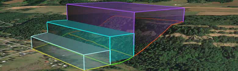
X-Rock Quarry Boundary 3D model
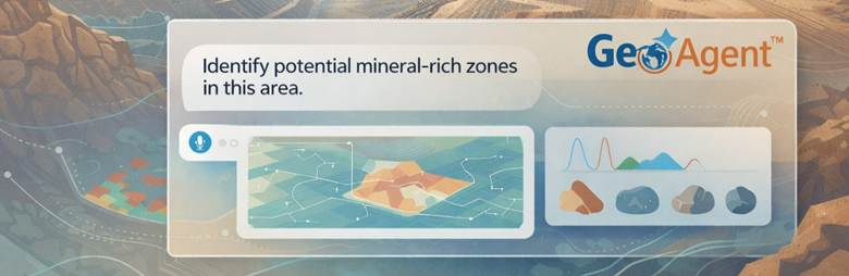
Introducing AI-Driven Exploration with ENVI GeoAgent
GeoAgent represents the next evolution of this workflow. Launched on February 3, 2026, by NV5, GeoAgent introduces artificial intelligence directly into the geospatial analysis process.
Rather than manually sourcing data, configuring tools, and executing complex workflows, users can now interact with the system conversationally. A geologist or planner can simply describe an objective, such as identifying areas likely to contain a specific mineral, and GeoAgent automatically assembles and executes the appropriate analysis.
Behind the scenes, GeoAgent selects relevant data, applies established analytical methods, and delivers results directly into the organization’s GIS environment. Just as importantly, it explains each step in clear, plain language, making advanced analysis easier to understand and trust.
Designed for Both Non-Experts and Specialists
GeoAgent is built to support a wide range of users across organizations.
For non-experts, it removes technical barriers. A user can ask GeoAgent to analyze uploaded data and identify critical minerals in a known mining region. GeoAgent handles the complexity automatically, publishes results to GIS dashboards, explains what was done and why, enabling informed participation without requiring deep technical expertise.
For experienced analysts, GeoAgent acts as an intelligent assistant. It recommends best-practice tools and parameters, automates repetitive tasks, and accelerates complex, multi-step workflows. Every decision is logged, creating transparency, auditability, and confidence in results. Analysts remain fully in control while benefiting from faster execution and cross-domain insight.
Scaling Insight Across the Organization
One of GeoAgent’s most significant advantages is scalability. It interprets user intent, orchestrates workflows, and delivers outputs that integrate seamlessly into planning systems and operational dashboards. This ensures that insights are not locked within specialist teams but can inform executives, planners, and field operations alike.
By making advanced geospatial analysis more accessible and transparent, organizations can align technical teams and decision-makers around a shared understanding of risk and opportunity.
A Practical Step Toward Intelligent Exploration
Together, ENVI and GeoAgent signal a meaningful shift in how mineral exploration decisions are made. Manual, time-intensive processes are augmented by intelligent automation. Subjective interpretation is complemented by repeatable, data-driven analysis. Insight becomes faster, more consistent, and easier to scale across teams.
For organizations seeking to reduce uncertainty, optimize exploration budgets, and accelerate discovery, adopting ENVI with GeoAgent is not just a technical enhancement. It is a strategic move toward more confident, informed, and resilient mineral exploration in the AI era.
Like to know more?
We’d love to hear from you! 🤗
Fill out the form below to share your thoughts or request a free consultation with our experts. Discover how GIS can streamline your workflows, boost collaboration, and elevate your project outcomes.
References
NV5 Global – Mining & Natural Resources Solutions
NV5 Geospatial – GeoAgent™ Solution Overview
https://www.nv5.com/geospatial/solutions/geoagent