Unleashing the Power of Hyperspectral Sensors With ENVI Software
The advent of advanced hyperspectral sensors has transformed remote sensing, enabling unprecedented detail and precision in applications such as mineral exploration, environmental monitoring, and agriculture. Hyperspectral sensors stand apart from traditional multispectral sensors in their ability to capture hundreds of continuous spectral bands across the electromagnetic spectrum. This rich spectral information enables the identification of materials, gas monitoring, and vegetation health assessments like never before.
ENVI® is the industry standard for processing and analyzing hyperspectral data, capturing the subtle spectral signatures in hyperspectral data to identify rare earth minerals and monitor greenhouse gas emissions.
Numerous hyperspectral sensors are currently operational or scheduled for launch in the next few years. These sensors vary in spectral range, spatial resolution, and application focus. Some are dedicated to greenhouse gas monitoring, while others focus on ocean colour or global imaging. They are deployed on platforms such as drones, aerial vehicles, satellites, and the International Space Station (ISS) such as the EMIT sensor from NASA JPL.
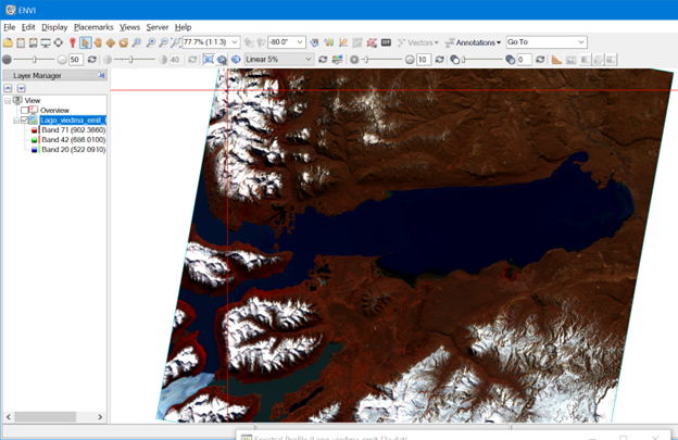
EMIT Hyperspectral imagery from the ISS of Lago Argentino, Glacier Perito Moreno.
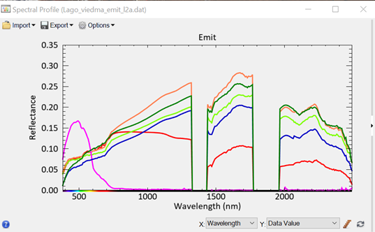
EMIT Spectra — note high quality and high signal-to-noise ratio.
Calibration is crucial for comparing data from different sensors. Various protocols can result in different on-orbit measurements, and even within collaborating partners, there can be discrepancies. The importance of calibration cannot be overstated when comparing data sets, as it can significantly impact the accuracy and reliability of the results.
Rare Earth Mineral Identification With Hyperspectral Sensors and ENVI
The identification of rare earth minerals is essential for industries such as electronics, clean energy, and defence. Hyperspectral sensors provide an advantage in detecting these elusive elements, capturing subtle spectral signatures that distinguish them from other materials. ENVI’s sophisticated spectral analysis capabilities, such as Spectral Angle Mapper (SAM) and Matched Filtering, allow us to pinpoint rare earth minerals with impressive accuracy.
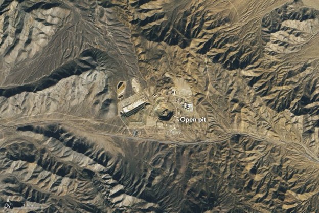
Mountain Pass, CA. Image Courtesy NASA DESIS sensor on ISS.
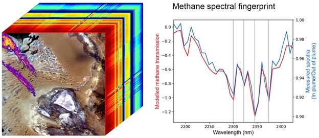
EMIT Jet Propulsion Laboratory, NASA. Turkmenistan. Purple streaks in left corner are Methane Emissions.
Monitoring Greenhouse Gases Using Hyperspectral Data and ENVI
Greenhouse gas emissions are a major global concern, driving climate change and threatening ecosystems worldwide. Hyperspectral sensors can detect and monitor these gases with remarkable precision, capturing the unique spectral signatures of methane, carbon dioxide, and many others. ENVI processes this hyperspectral data and generates detailed maps that show the spatial distribution and concentration of these gases, empowering decision-makers to take targeted action in mitigating their impact.
Beyond Minerals and Gases: The Expansive Potential of Hyperspectral Data
The applications of hyperspectral data and ENVI extend far beyond rare earth mineral identification and greenhouse gas monitoring. This technology offers invaluable insights into vegetation health, water quality, soil composition, and even urban planning. As the remote sensing landscape continues to evolve, the power of hyperspectral data when analyzed by ENVI will play an increasingly critical role in shaping our understanding of the world around us.
ENVI is a powerful tool that extracts information from hyperspectral data, unlocking new opportunities for research and innovation. As the industry leader in hyperspectral processing and analyses, we are excited to witness and contribute to the growth of this transformative technology.