Spatial Analysis (NDVI) of Basin in AMAC, Abuja Nigeria
The Normalized Difference Vegetation Index (NDVI) analysis, is critical for managing urban greening and the thermal environment. The biophysical components of the environment are constantly changing daily due to vegetal removal, environmental degradation, and atmospheric pollution.
The changes have resulted in an increase in environmental temperature and an energy imbalance. The Normalized Difference Vegetation Index (NDVI) is a Remote Sensing (RS) index that measures the difference between near-infrared (NIR) that vegetation strongly reflects and red light (R) that vegetation absorbs to quantify the amount of vegetation in a given area.
When the NDVI value is negative, it indicates the presence of water; when it is close to +1, it suggests the presence of dense green leaves; and when it is close to zero, it indicates the absence of green leaves, which could indicate an urban area. As a result, urbanization has impacted NDVI values in cities, as cities account for only 2% of the total global surface area but house over 50% of the human population. The urbanization process has resulted in the widespread removal of vegetation from urban surfaces and replacing these with urban fabrics capable of increasing thermal fluxes, resulting in human heat discomfort in urban areas.
This research seeks to analyse the Normalized Difference Vegetation Index for agricultural purposes in the lower part of the River Niger.
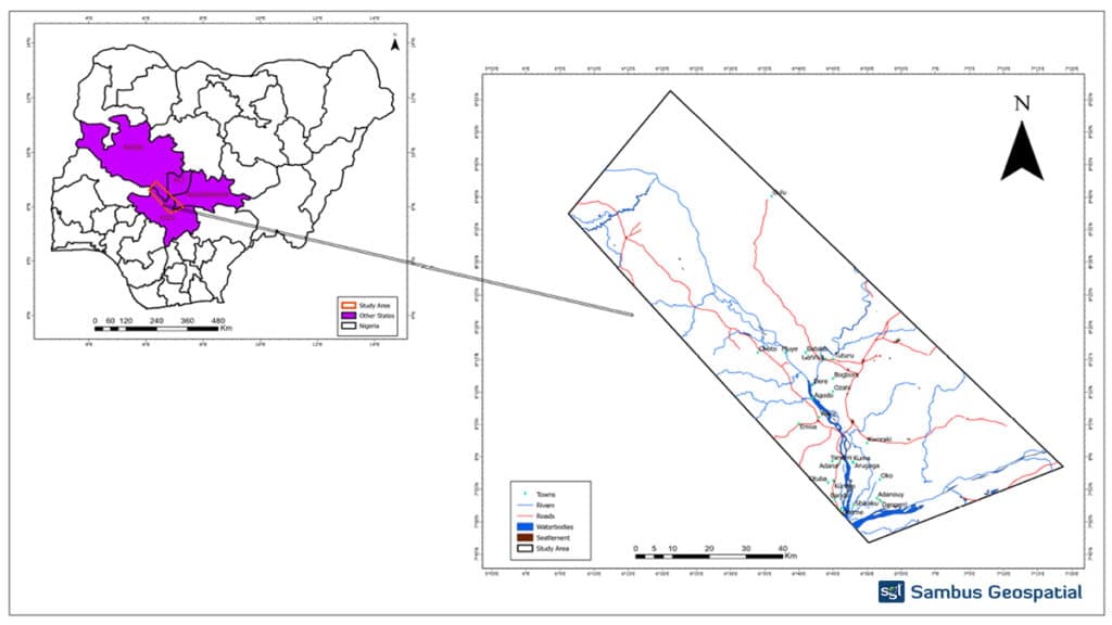
The Study Area
The study area cuts across FCT, Nasarawa, Niger and Kogi state, respectively.
Kogi State is one of Nigeria’s 36 states, located in the country’s Middle Belt. Kogi State, formed in 1991 from parts of Kwara and Benue states, is notable for being Nigeria’s only state that borders ten others. The confluence of the River Niger and the River Benue occurs in Kogi State’s capital, Lokoja, earning it the nickname “Confluence State.” Kogi State is a crucial centre of commercial trade in Nigeria due to its strategic location in the middle of the country and access to these significant rivers. Igala, Ebira, and Okun make up most of Kogi State’s population. Agriculture continues to be the mainstay of the Kogi State economy.
Methodology:
NDVI (Normalized Difference Vegetation Index) is an indicator of plant health. It is calculated based on visible and near-infrared light reflected by vegetation. Healthy and unhealthy vegetation reflect and absorb these light spectres differently.
Landsat 8 satellite image was downloaded from glovis (https://glovis.usgs.gov/). The satellite image bands 5 4, representing the Near-infrared and Red, were used to process the imagery to analyse the NDVI of the study area.
The ArcGIS Pro Raster Calculator toolbox was used to process the satellite imagery. The satellite bands were inputted into the fields according to the Near infra-red band; band 5, and the Red band, Band 4 in which the NDVI formula was used.
NDVI is calculated using the following formula:
NDVI = (NIR — R) / (NIR + R)
NB: NIR: Band 5
R: Band 4
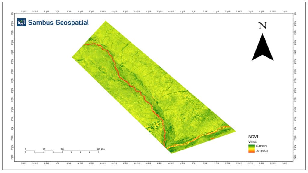
The figure above shows a vegetation range of -0.119541 to 0.449625, which shows how healthy the vegetation is in the study area. The areas in red depict no or lack of vegetation while the yellow ones show unhealthy vegetation, and areas with deep green have healthier vegetation.
This analysis further shows the capability of the ArcGIS Pro Software to Vegetation Indices analysis.
Project by Sambus Geospatial Nigeria Limited.
For more information contact Quadri Adebayo – qadebayo@sambusgeospatial.com
Software: ArcGIS Pro 2.7.2.
Data source : Landsat 8 OLI – https://glovis.usgs.gov/