What’s New in Learn ArcGIS April 2022
Take part in a step-by-step learning series on the application of Key ArcGIS tools and Workflows in real world Scenarios. The latest lesson updates in the Learn ArcGIS Gallery for April Includes
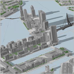
Creating Web Scenes to Support Construction Planning
Create 3D Scenes of Rotterdam City with Basemap Elevation Information in ArcGIS Pro and ArcGIS Online. The 3d Scenes created can used as an accessible backdrop for visualizing other projects.
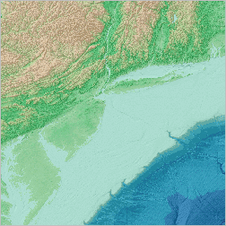
Finding ocean bathymetry data
Study the ocean floor off the East Coast of the United States and visit a variety of online data portals to find different bathymetric datasets in ArcGIS Pro and ArcGIS Online.
Getting started with notebooks in ArcGIS Pro
Learn how to automate workflows using Python Scripts in ArcGIS Pro. Learn how to write the codes to locate areas with variation in proximity to fire department services among other functions.
Visualizing an ocean canyon in 2D and 3D
Learn how to manage resources by mapping, measuring, and visualizing bathymetric in the ocean and coastal environment in ArcGIS Pro. This new lesson helps you learn bathymetric terrain mapping in both 2D and 3D.
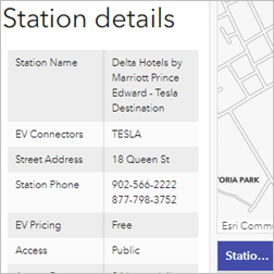
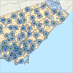
Build an interactive dashboard
Build interactive dashboards that allows users to find charging stations for electric vehicles in Canada. As electric vehicles become more popular, knowing where charging stations are is important.
New Learn Paths
The learning path for ArcGIS Lessons have been updated with a new set of resources. The most recent learning path update in Learn ArcGIS include the use ArcGIS Image for ArcGIS Online to host, analyze, and stream imagery and raster collections in the cloud.
More Information on Learn ArcGIS April 2022 Updates
Visit Esri Community to see all details on the April 2022 Learn ArcGIS Platform.
Source: Adena Schutzberg 2022, Esri, accessed 10 May 2022, <Esri Community>