The Nigeria GeoPortal
The Nigeria GeoPortal is a one-stop-shop for open geospatial datasets in the Nation which avails you the opportunity to access a variety of geospatial tools, open data, training, and learning resources to help you grow your geospatial skills and enrich the existing resources via contribution.
The launch of the Nigeria Geoportal is one of the exciting news to the geospatial community in Nigeria. It was officially announced on the social media pages of the Africa Geoportal and Sambus Geospatial Nigeria Limited on the 8th of April, 2021. The platform is powered by Nigeria’s National Statistical Agency, a governmental agency that provides accurate, timely, continuous, and sustainable basis, socio-economic statistics on all facets of development in Nigeria alongside ESRI, the global market leader in providing GIS solutions and products. The platform leverages the ESRI’s ArcGIS Hub, an easy-to-configure cloud platform that organizes people, data, and tools to accomplish initiatives and goals as the underlying technology.
What is a Geoportal and Why We Need One?
Geoportals are web-based portals used to discover, access geospatial data and services, analyse, edit, and visualize spatial data on the internet. Geoportals are important for the effective use of geographic information systems (GIS) and a key element of Spatial Data Infrastructure (SDI).
Over the years, several Governmental Agencies, NGOs, Private Organizations, and MDAs have embarked on data collection exercises with an overarching goal of acquiring location-based data and attributable information that are important for their various use cases. Meanwhile, some of this data already exists in some other organizations’ data banks but are sometimes not made open and easily accessible by users in the general populace. Perhaps, due to several constraints, confidentialities, and policies around the use of these data, technical requirements in setting up a fully-fledged and highly efficient data portal, unawareness of existing data portals, poor quality of existing data among other reasons.
However, these data are very crucial in the execution of their development and high-impact projects, hence the need for the data collection exercises can be justified. This repetitive and continuous effort, that consumes time and human resources suggests the need for a unified open data portal where high-quality data can be contributed to by organizations and individuals for easy access to the users. Why can’t we have a unified portal to host local data specific to Nigeria? Why can’t we continue to update existing data rather than collecting new data that leads to data redundancy? All these efforts lead to data disconnection, and these are the problems the Nigeria GeoPortal would provide solutions to if embraced and well harnessed.
Mr. Biyi Fafunmi, who is the Head of National Data Archive and spokesperson for the Nigeria National Statistical Agency (NBS) in an interview mentioned that NBS is by law the apex and National Statistics office in Nigeria, NBS is expected to co-ordinate the entire national statistical system, develop, and promote best statistical standards and uses. Not only that, NBS is to develop and maintain a national data bank that will act as a focal point of accessing statistical information. NBS became involved with the Africa Geoportal in less than a year ago prior to their interaction with the Esri team and the aftermath of creating the Nigeria Geoportal.
Benefits of the Nigeria GeoPortal
Mr. Fafunmi also stated that the Nigeria Geoportal will therefore solve among other problems the issue of having access to geospatial data, reduce the problem of conflicting data, cost of maintaining online geoportal, create opportunities for more people in learning GIS and its applications, data interpretation will be made easy as well as a better understanding of data for decision making and easy sharing of data.
The Nigeria GeoPortal hosts data that are contributed by organizations and individuals on a single portal for access to analysts, researchers, and interested organizations that want to use data for projects that require spatial analysis to inform decision-making. In the case that a portal like the Nigeria GeoPortal existed earlier, many of the data collection exercises being carried out would have been abolished, as most of the required data about Nigeria are found on the platform which would have saved a lot of resources.
A registration on the platform has been made easy with a click here to have full access on the platform. The below are some of the interesting things you can do on the Nigeria Geoportal:
On the platform you can discover a reliable collection of focused geospatial data collected from Esri, Esri partners, governments, and existing open data. You can also share your data and enrich the collection.
While it is important to have a unified data portal, the quality and integrity of the data is more important to the GIS practitioners. This was in the picture in the entire process of the platform development and the topic was also discussed during the 2020 GIS day event organized by the Sambus Geospatial Limited. It was ascertained that the data on the platform are of high quality as they are required to pass through quality and integrity checks before approval on the platform.
Using the portal, you can have free access to the best geospatial tools, make maps, perform spatial analysis, and create web applications. Use the data on the platform, bring your own, or combine them.
You can make the most of the free geospatial tools with online resources. Introductory to expert resources available and a community of like minds that are willing to always help provide answers to any of your questions.
Why Open Data Matters
To see the changes we all desire, we need to embrace open data and encourage the sharing of data for use by problem solvers. As GIS is data-driven, little or nothing can be done without access to the right data. Having access to these data would not only unlock innovations but also spark ideas that can solve pressing problems and cause the change needed as a Nation. This was the key takeaway from the discussion in the webinar hosted earlier by the Sambus Geospatial Nigeria Limited on the Open data day event in March 2020. The webinar recordings can be accessed on the YouTube page or with a click on the link here.
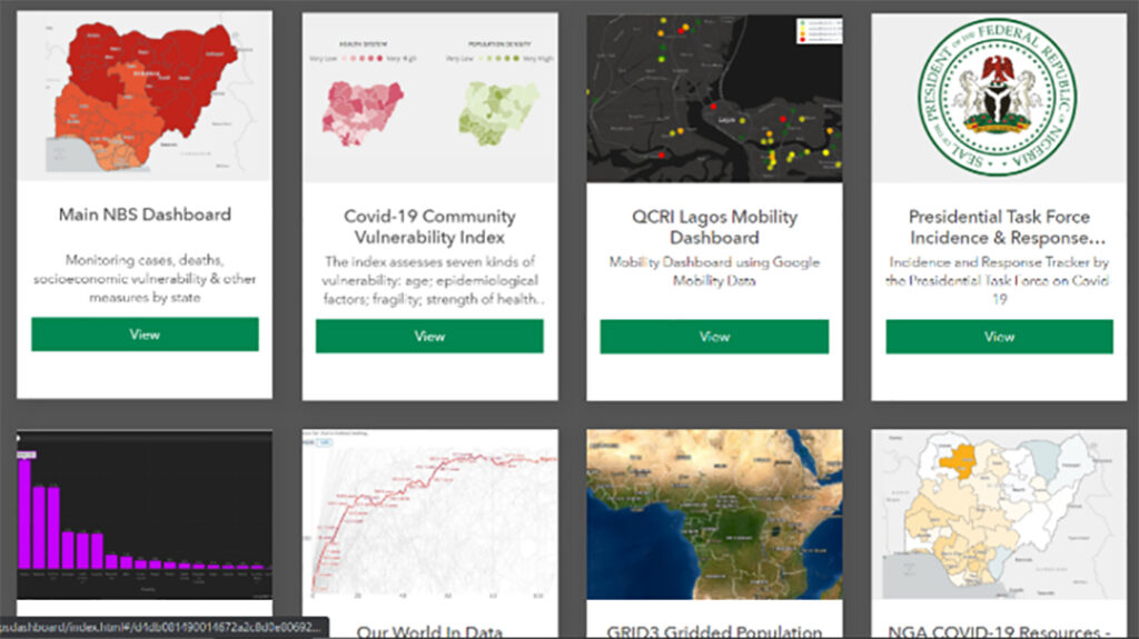
Moreover, NBS encourages all members within the Nigeria National Statistics system to join the Nigeria Geoportal by sharing their geospatial data and analysis on the portal as done on their earlier established COVID-19 Datahub.
Finally, Mr. Biyi noted that the NBS is ready to share their GIS resources in the portal and build capacity where necessary. He advised that the users of the Nigeria Geoportal should keep on using the portal as frequently as possible, give feedback to better improve the portal, share citations to better enrich the portal, and always visit the portal for a new update. The Nigeria GeoPortal has been developed for use. It is our responsibility to put it to good use by sharing quality data on the platform and spreading the word to the GIS professionals and gatekeepers in our network.
If you haven’t already, click here to join the Nigeria GeoPortal today and enjoy the amazing benefits it has to offer.